


The Republic of Azerbaijan is typified by relief of different kinds and complexity. Over half of the country's area consists of the mountain ridges, crests, plateaus rise up to hypsometric levels of 400-500 m, (or up to 800-1000 m within the Middle and Lower Araz lowlands), in some places (Talis, Jeyranchol-Ajinohur and Langabiz-Alat for ranges) up to 100-120 m, as well as 0-50 m up (Gobustan, Absheron) the rest part of which are plains and lowlands.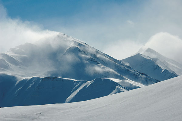 Hypsometric marks within the Great Caucasus region vary in the range from about -28 m at the Caspian Sea shoreline up to 4466 m, (Bazarduzu peak). Quantitative area distribution according to their hypsometric levels is as follows: 18% of the area is located below the Ocean level, 24%-has hypsometric marks ranging from 0 to 200 m, 15.5% are covered by areas which elevation ranges from 200 to 500 m, another 15.5% are covered by areas which elevation marks ranges from 500 to 1000 m, 19.5% are covered by areas which elevation ranges from 1000 to 2000 m high, 6.5% are covered by areas which elevation ranges from 2000 to 3000 m, and only 1% is the areas which elevation marks are over 3000 m high. The average elevation is 384 m high. Principle orographic units of Azerbaijan Republic consists of the Great Caucasus mountain system, Samur-Davachi lowland (in conjunction with Gusar inclined plain), Kur River lowland, Minor Caucasus and Talish mountain systems.
The only southeast part of the Great Caucasus mountain region is located within the Azerbaijan Republic. The basic orographic elements of this part of the Great Caucasus system are the Major Caucasus system (or watershed ridge) and the Lateral ridge. Major Caucasus ridge constitutes a large portion of the Great Caucasus system and extends southeast off Tinov-Rosso elevation (3385 m) is located at Azerbaijan State border with Georgia and Daghestan AR. The only southern flank of the ridge between Tinov-Rosso and Bazar-Duzu (the northern flank of the ridge belongs to Daghestan AR), where both flanks of that part belong to Azerbaijan. The Major Caucasus watershed ridge is not crossed with any river valleys (and therefore it is also called Watershed ridge). Most part of the ridge elevation is over 3000 m high, and only in its central part, it exceeds 4000 m height (Bazar-Dyuzu - 4466 m, Tufandagh-4191 m, Bazaryurd- 4126 m). Beginning from Babadagh peak (3629m) the same ridge elevation gradually goes down and becomes wider. Starting from Dubrar elevation (2205 m) Major Caucasus ridge plunges northeastward towards the Caspian Sea like expanded fan having been cut by river valleys into separate ridges like Gadi-Kurkachidagh, Aladagh, Kemchi, and others. The same ridges are further divided into smaller and lower ridges to pass into low elevation mountain region named Gobustan, and further on into Absheron Peninsula. North off and parallel to the Great Caucasus ridge, there is a southeast trending ridge called Lateral, of which the Azerbaijan section starts from the Shahdagh (4243) extending and getting lower southeastward and terminates at Beshbarmag (546m) pinnacle. Lateral ridge is divided into stand-alone blocks-Plateaus (Shahdagh, Gizilgaya, Budugh, etc) by river valleys that begin from the Great Caucasus ridge. Northeast off and parallel to the Lateral ridge there is Talabi-Gaynarja elevation (which elevation ranges from 1000-1100m in the west down to 150-200m in the east). Ridges and elevations are divided from each other by valleys and intermontane troughs (Shahnabad, Khinalig, Erphee, Gonagcand, Kaltan, Gilgilchay, Tigchay, Rustov, Perebedil, etc). The southern flank of the Great Caucasus ridge descended down to Alazan-Ayrichay valley(in some sources Alazan-Haftaran valley, whereas in others it is considered as one of the Kur River valley parts) that in some places is parallel to the mentioned ridge. Said above valley begins from the Georgia Republic and is 210 km long and 30 km wide in Azerbaijan. Nialdagh ridge which elevation reaches up to 2100 m high is extended parallel to the Great Caucasus one apart through Lahij valley
Samur-Davachi lowland is extended along the Caspian shoreline from Samur River to Sumgayit-chay. Its portion located in between Atachay and Sumgayit-chay is called Boghaz plain. This lowland in the northwest (at 200-250m hypsometric level) passes into Gusaz inclined plain through a 10-25 m high bench. Gusar inclined plains in the southwest reach Lateral ridge where its elevation mark amounts to 19000 m (Boyuk Suval) Lowland hypsometric level on Caspian shoreline level is 28 m below the ocean level.
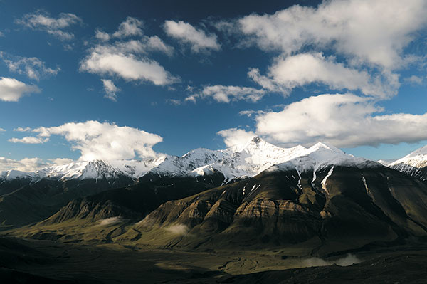
Azerbaijani part of the Minor Caucasus consists dominantly of several variously trending ridges that are not the main watershed ones including Murovdagh, Karabakh, Michtocan, systems, partially Shahdagh, Shargi-Goycha (Shargi Sevan), Zangazur, Daralayaz mountain systems, volcanic plateau (most of Karabakh plateau) and Bashcand-Dastafur etc lowlands (in some publications Zangazur and Daralayaz systems, as well as Karabakh plateau, do not refer to the Minor Caucasus). Shahdagh ridge extends off the same elevation (2901 m) in the northwest and towards Hinaldagh elevation (3367 m) in the southeast. Murovdagh ridge extends north off Hinaldagh elevation through Gamishdagh elevation (3724 m). North off those ridges there is Bashcand-Dastafur lowland and even more to the north there is Shamkir vault elevation. Pant ridge and stand-alone Kapaz elevation (3030 m) separate Bashcand-Dastafur lowland in the north from Aghjacand lowland. Minor Caucasus north flank ridges get lower to the north and abruptly pass into Ganja-Gazah plain within Middle Kur River valley through steeply plunging flanks. East Goycha (East Sevan) ridge serves as a watershed for Tartar River and Sevan Lake drainage systems. Its highest elevation is Ketidagh (3437 m). Minor Caucasus southeast termination known as Karabakh ridge gets lower towards Araz River valley and passes into foothill inclined plain. Its highest elevation Gizgala (2843 m) Girhgiz (2830 m) Boyuk Kirs (2725 m) from stand-alone rocky elevations overbroad and smooth watershed background within the northern part of the ridge. Over the ridge north flank, there are transversal crests and depressions. Karabakh ridge jutted out with latitudinally trending Mikhtocan ridge (Dalidagh, 3613 m) in the northwest. Zangazuz and Daralayaz ridges southwest and south flanks respectively belong to Azerbaijan Republic (within the Nakhchivan Republic). Zangazyr ridge is extended down to Araz River valley.
This ridge is the highest among the Minor Caucasus mountain system which an average height is 3200 m. The highest elevations of the ridge (Gapijik, 3906 m, Gazandoldagh, 3814 m, etc) are situated in its southern part. A great number of transversal crests are extended southwestward off the ridge. Different kinds of stand-alone extrusions and laccolith bodies are typical for their fore-range portion (Ispandagh-2410m, Khanaga-1910m, Alinja-1810m).
West off Zangazur ridge there is Daralayaz ridge (Kukudagh-3210 m, Kechaldagh-3115 m) that gradually descends towards Araz River valley. South of the ridge within its fore range part there are dominantly plateaus and crests (Givrag, Duzdagh, etc). 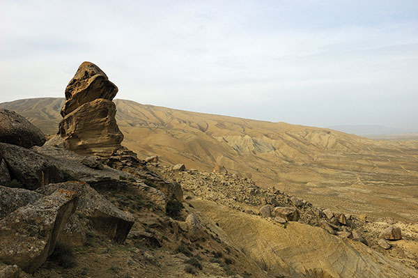 Both ridges south and southwest foothills pass into plains extended along Araz River left bank and divided apart from each other by elevations and crests (Sadarak, Sharur, Boyukdyuz, Nakhchivan, Julfa, Yayji, etc). Karabakh plateaus occupy a relatively wide area where large extinct volcanic necks are jutted out in between Zangazur and Karabakh ridges over the rolling surface (Gizilboghaz-3581 m, Boyuk Ishigly-3552m, Ala Gollar-3175 m, etc) in between Zangazur and Karabakh ridges.
Here, the average elevation varies in the range from 2000 to 2500 m. Plateau gets narrower and its height descends southward and finally terminates at the interflow point of Bazarchay and Hakarachay Rivers.
Talish mountain system is located southeast of the Lower Araz River valley (some explorers consider that Talish mountains are suggested to be the Alborz system northwest extension). This mountain system consists of almost parallel and northwest to southeast extended Talish, Peshtasar, and Burovar ridges. The longest of them (about 100 km long) which elevation reaches 2500 m high is the Talish ridge trending along the State border with the Islamic Republic of Iran. In some places, those ridges join to each other through transversal ridges that form stand-alone intermontane troughs (Yardimly, Zuvand, etc). Lankaran lowland is located in between Talish mountain and the Caspian Sea.
Kur River valley occupies the central part of the Azerbaijan Republic. Its relief consists of vast plain terrane and foothill areas. The main orographic feature of the valley that lies in between Great and Minor Caucasus systems is the Kur-Araz lowland terrane the largest one in the south Caucasus region. The lowland terrane is divided by Kur and Araz Rivers into Mil-Karabakh, Shirvan, and Mughan-Saliyan plains. West and the central parts of the Kur-Araz lowland terrane lies some 28 m below the ocean level. Its foothill area elevation varies in range from 100-250 m and in some places up to 400-500 m high. Anja-Gazah inclined plains in the northwest are extended along the Kur River right bank whereas Anaghy-Arazboyu inclined plains in the southwest are extended along the Araz River left bank. North off Ganja-Gazah inclined plain and Kur-Araz lowland there are Jeyranchol, Ajinohur, and Langabiz-Alat foothill terranes. Ajinohur foothill terrane, which elevation reaches up to 1100m high, consists of several ridges, crests, as well as lowlands and valleys dividing them from each other is extended along the south margin of the largest of them Alazan-Ayrichay valley.
Elevation terrane ranking
 The complexity of the Azerbaijan Republic relief provides an opportunity to carry out its vertical ranking as follows: the high mountain terrane, intermediate-level mountain terrane, low-level mountain terrane, and plain-lowland terranes.
The high mountain terrane embraces areas over 2500, high. In this context, the Great Caucasus system consists of Major Caucasus and the Lateral ridges. Minor Caucasus high mountain terrane includes basically lateral parts of Zangazur, Mishovdagh, and Shahdagh ridges that in many places look like narrow zones. Due to poorly developed vegetative cover, this terrane is characterized by cliffy and rocky topography. Here, there are many taped and pectinal elevations. Besides, there are relics of the ice-worn relief (trough valleys, cirques, and corries). Also, there are small contemporaneous glaciers. Mountain slopes are covered with thick clastic debris cones.
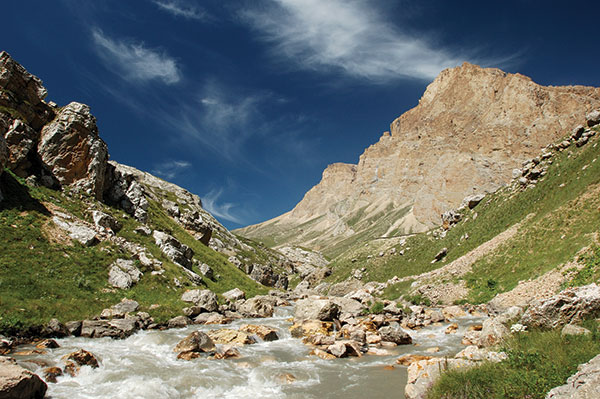
Intermediate-level mountain terranes occupy most mountain systems which elevation varies in the range from 1000 to 2500 m high, and is dissected by deep river gorges. In areas where river gorges become wider, particularly within intermontane valleys, there are many terraces, and staggered leveling plains are pervasive. In some places, there are occurrences of landslides and rockfalls.
Low-level mountain terrane embraces areas which an elevation of about 200 m high (Gobustan and Ajinohur) and about 50-100m high within foothill areas. In this terrane, the hillsides are gentle and watershed areas are smooth. In some areas (Gobustan, Jeyranchol, and Ajinohur foothills and Nakhchivan AR foothills) lack of moisture promotes arid-denudation processes evolvement that resulted in badland landscape, clay cast, and other relief forms development.
The plain-lowland terrane embraces areas which elevation varies in the range from 100-200 m, in some places to 400-500 m (and from 800-1000 m within the Nakhichevan Republic). This terrane includes most of the Kur River and Samur River lowland areas, Alazan-Ayrichay valley, Araz River nearby plains, etc. Aggradation terraces are widespread here. The main relief forms within the foothill areas are alluvial cones and dunes within the Caspian coastal area.