


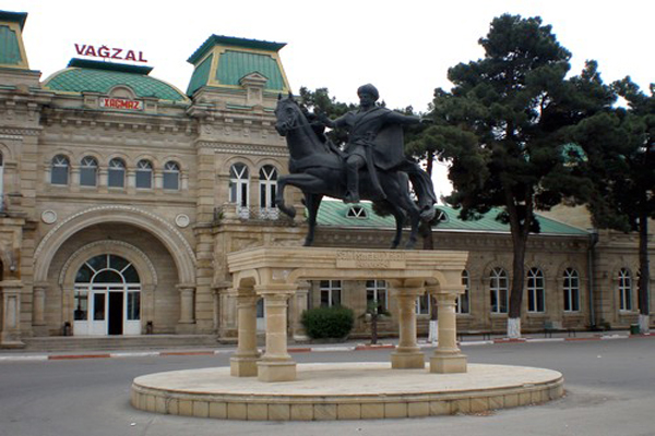
NORTH ROUTE: KHIZI— SIYAZAN— DAVACHI— GUBA — KHACHMAZ— NABRAN— GUSAR
KHIZI
KHIZI district is located in the Guba-Khachmaz region of Azerbaijan. Khizi is the closest to Baku among the administrative regions of the republic with mountainous terrain: the distance between Baku and Khizi is only 70 km. The climate in this region is mild-hot and precipitation falls less. The eastern part of the district is the Caspian coast.
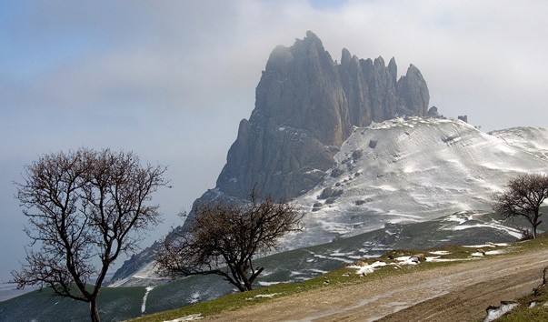
On the road to Khizi, 10 km from the BAKU-ROSTOV highway, one can observe a very interesting natural phenomenon: layers of geological rocks create on the surface of hills a landscape of its own color. Experts say that a similar geological phenomenon can only be found on earth, except here — in the Valley of death in the United States.
One of the most beautiful reserves of the Republic, "ALTIAGHAJ" Reserve is located in Khizi district. 90% of its area consists of forests. This reserve was created to preserve rare species of animals and plants on the south-eastern slopes of the Greater Caucasus and to prevent erosion processes from taking place here. One of the caravan camps established during Shirvanshahs ' rule was located here. The meaning of the name "Altiagach" is related to the words "6 trees": the point is that the word "tree" is an ancient unit of length and is approximately 7 kilometers.
Since the distance from Altiaghaj to Shamakhi is 42 km, that is, "6 trees", this place was named as such. The ancient caravan route linking Shamakhi and Derbent passed here. Lovers of pedestrian tourism still make tourist trips from here to Maraza and Shamakhi. Yashma Reserve is also located in the territory of Khizi region (near Sumgayit city). The Reserve, which covers an area of 4 hectares, has favorable conditions for hunting and fishing for water birds.
The administrative center of the district is KHIZI city. The distance from Baku is 104 km. Khizi is the homeland of the famous writer and playwright of Azerbaijan, Jafar Jabbarli who has done a lot for the development of national cinema art. At present, the Azerbaijan State Film Studio bears his name. Well-known cultural figures of Azerbaijan Mikayil Mushfig and Jabir Novruz are also originally from Khizi. For travelers, tourists, and simply vacationers who come here, a wonderful recreation area called "Paradise Garden" has been created near the city. This zone is located in the mountain forest, on the Bank of Atachay River, near Altiaghaj Reserve. 8 km from Khizi there is another recreation area called "GIZILGAZMA".
SIYAZAN
Siyazan district is located in the north of the capital of Azerbaijan, along the coast of the Caspian Sea. Climate dry semi-desert climate, the landscape consists of sparse forests and shrubs. Wolves, wild cats, jackals, rabbits, and other species are common in the animal world. Several species of waterfowl can be found in the coastal zone. GILGILCHAY and ATACHAY rivers flow through the territory of this region.
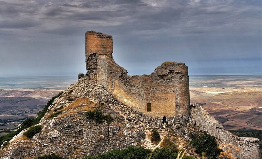
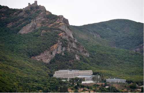
During the early Middle Ages, the second line of the Caspian defense fortifications was passing here (the first line of these fortifications is in Derbent). This line is included in the list of historical and cultural monuments protected by the state of Azerbaijan. GILGILCHAY defensive fortification was also recommended by UNESCO to be included in the list of World Heritage Cultural Monuments in the complex "Caspian defense fortifications". Archaeologists have established that the construction of the defense fortification Gilgilchay began long ago, even before our era, additional construction works were carried out and the fortification was further strengthened.
The walls of the fortifications begin directly inside the sea (for many years the water level in the Caspian Sea has undergone periodic changes). The fortress walls, stretching for several kilometers, ending in the magnificent CHIRAGGALA Watchtower (V century). It is worth climbing this tower: its historical significance lies in its place, looking from the top of the mountain, a very beautiful view of the sea and the surrounding mountains opens.
Here, between the sea and the foothills of the Caucasus Mountains, there is a convenient passage for travel from Azerbaijan to other countries in the North. From ancient times, the invaders who came from the territory called the Caspian passage from neighboring states and distant provinces entered the territory of our country. They attacked Azerbaijan, made robberies in the port of Baku, sometimes even went to the districts in the inner part of the country. Therefore, this fortification was of defensive nature and was used to deliver signals to Absheron (Baku) and later to all border regions of ancient Azerbaijan. The dimensions and defensive purpose of the fortification walls (he also protected the passage to the Great Silk Road) make it possible to compare it with the Great Wall of China, but this facility has not been restored yet.
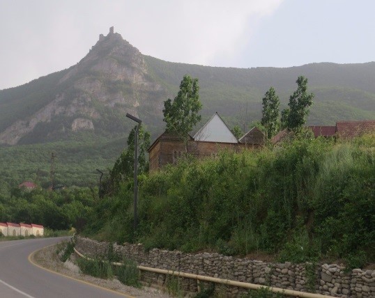
In the resort town of GALAALTI, located just a short distance from the Chirag gala Tower, the Chiraggala sanatorium attracts attention. On its territory, there is a spring of sulfur-containing mineral water, which has a curative value. This water is especially useful for patients with stones in the urinary bladder and gallbladder. Along the way to the sanatorium, there are numerous kebab houses, cafes, and small campsites. Most of them work only in summertime.
Fragments of another defensive fortification Beshbarmag near ZARAT village were preserved. Among the people, these remains are called baba in Khizirzin. And near the village of Sedan, the remains of the religious fortress attract attention.
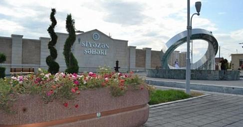
Carpet weaving patterned carving on wood, making of folk musical instruments are widely developed in this region. The center of the district is 103 km from the city of Siyazan.
There is no hotel in Siyazan. Therefore, those who come here can stay in private houses or in the Chiraggala sanatorium, which is a little distance from the city. If you want to have lunch in Siyazan, you can use the services of "GORUS", "ZAFARAN" or "CHIRAGGALA" restaurants. As the city is located near the Caspian Sea, these restaurants offer a wide range of fish dishes in meat and vegetable dishes.
SHABRAN
Located in the north of Baku, the eastern border of the Shabran region stretches along the coast of the Caspian Sea. Such a name of the district is probably due to a large number of camel caravan routes here. Residents of this region used to keep camels, and visitors from neighboring regions bought and sold not only camels, but also birds, animals, butter and dairy products, honey, wool (camel and sheep wool), and carpets. In addition, there were those who came to join the caravan or rent camels and sarvan for themselves. In 2010, the name of Davachi district was changed to Shabran district.
A hunting farm called Aghibir was established in the territory of devechi district at a distance of 12 km from the Sea coast. With an area of 1180 hectares, the farm can hunt waterfowl and fish. Three interconnected lakes, located in Agzhibir, have access to the sea. There are also small houses and boats to welcome hunters. There are a lot of forests (21,500 hectares) in these forests: bears, foxes, wolves, jackals, wild boars, and gazelles. Birds, including water birds, can be found as turaj, Partridge, goose, duck, crane, Cormorant, coot, and other species. The relief of the territory is very diverse. Here, along with Plains, foothills, there are also rocks and mountains. The place called kechigaya is very popular among both tourists and local residents. Here the river flows through the rocks, and mineral springs containing a lot of sulfur attract attention. The most famous historical monument of Archaeology in the region is Shabran city (5-18 centuries), located near the village of Shahnazarli. Shabran was one of the largest trade and craft centers of Azerbaijan in the Middle Ages. The art of silk production, pottery, and glazing were particularly highly developed here. As a result of archaeological excavations carried out in the 80s of the 20th century, the discovery of many ceramic products imported from both local and other countries shows that Shabran had local trade relations with some countries of the East. Fragments of water pipelines built in 14th century were also discovered during archaeological excavations. This pipeline supplied the city with drinking water from a fountain located more than 10 km from the city.
Galaalti is an original and extremely attractive balneological resort of Azerbaijan. It is located in the picturesque foothills of the Greater Caucasus at an altitude of 1000 m above sea level. Crystal clear air, located on picturesque forested slopes on the shore of the Caspian Sea, is a place of special natural beauty. Here mountain air merges with sea air and creates a low humid climate, which makes people feel comfortable. "Galaalti sanatorium" is especially useful for the treatment of kidney stone disease in medical and recreational resort complex in the territory of which there is a new unique architectural style and a mineral spring with curative sulfur water. The area is rich in mineral waters and mud volcanoes. Oil reserves have been found in the depths of the oxidized-Zeyva forests. On the way, you can see many oil rigs. There are two historical and archaeological monuments on the territory of the district. As for Shabran, we first get to know Chiraggala Castle. The meaning of "Galaalti" in Azerbaijani is "lower than the tower." The name of "Chiraggala" Castle is directly related to the fact that it is located at the bottom of the fortress.
Gulistan Iram City (18-19 centuries) is located in Gandob village. Numerous archaeological sites dating back to 3-2 centuries BC were found in the Shabran district. The materials found during the excavations can be found in the historical and local lore Museum in Shabran.
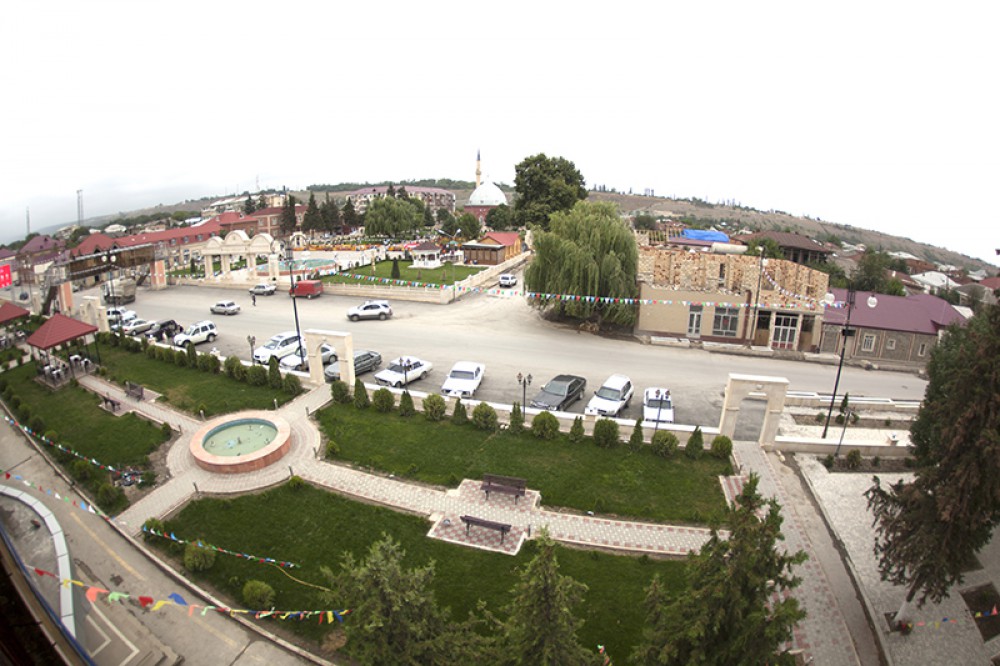
The administrative center of the district, Shabran city, is located 122 km from Baku. Local" PIRABEDIL "and" HERAT PIRABEDIL " according to the classification of specialists belong to the Guba carpet school. These carpets, which are original and unique, are popular among lovers of hand-woven carpet products.
Shabran city is an administrative center located 122 km from Baku. Shabran was founded in the V-VII centuries. In the IX-X centuries, it became the main political-administrative, trade-cultural and cultural center of the state of Shirvanshahs. In the middle of the XI century, the Tomb of the Shirvanshahs family was located in Shabran. The name of the city was later given to the environment.
GUBA
Guba district is one of the most developed agricultural regions of Azerbaijan. Fruits and vegetables grown here are exported to the capital markets, processed at local canning industry enterprises, and also exported to other countries. Despite a large number of fruits and vegetables grown in the Guba region, every Azerbaijani remembers his apple orchards when he says "Guba".People who sell apples in Baku markets, while praising their goods, certainly emphasize that it is a Guba purchase. Guba region, which has a rich flora, is also represented by a wide range of medicinal plants. Hawthorn, Juniper, nightshade, andis, devadaban, effedra, and a number of other medicinal plants are grown here.
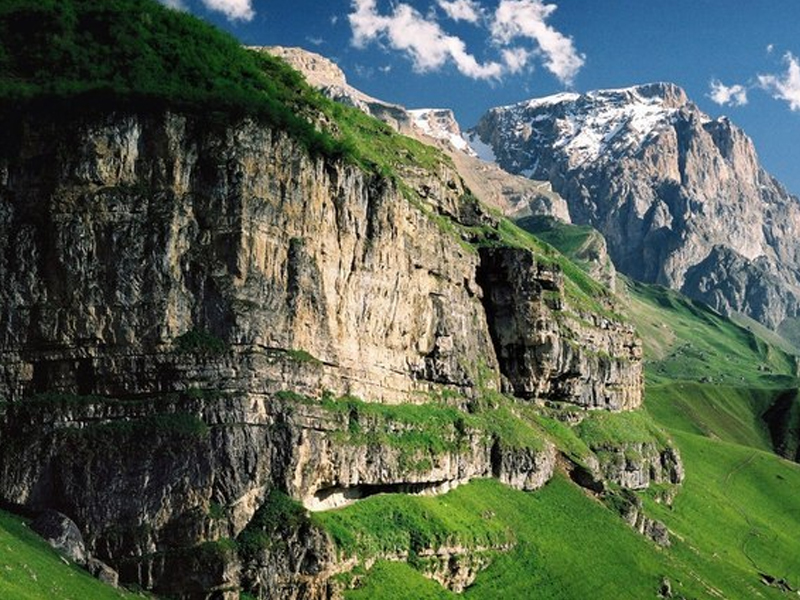
There are many picturesque corners around Guba. Gachresh, Balbulag, as well as Tangaalti ravine, the depth of which is from 400 to 600 meters, have become particularly popular and are of great interest to tourists.
The famous AFURJA waterfall on Valvalachay is included in the list of natural monuments of Azerbaijan and is protected by the state. There are other waterfalls here that attract the attention of tourists and travelers due to their uniqueness and uniqueness. It is a pleasure to stroll through these picturesque places on tourist trails. As you ascend to the mountains, tall trees are replaced by bushes, and above — on the Bank of Khashichay River thermal waters flow from the rocks of the mountain gorge. In ancient times, skilled craftsmen created three holes in rock and made self-made baths, and built their edges with stone. Those who come here can bathe in healing hot water containing sulfur-hydrogens in these baths. According to competent people, a bath made of natural stone enhances the healing effect of water.
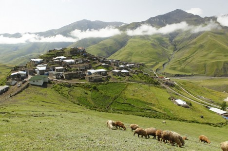
The famous French writer Alexander Dumas visited these places while traveling to Azerbaijan. When he camped near the road, the people of Guba camped nearby invite him to their bonfires in order to relax and have a snack. It is very impressive how the people of Guba skillfully cut and clean the sheep and share it with Dumas. The biggest traveler of our time, Norwegian scientist Thor Heyerdahl also visited Guba during his visit to Azerbaijan. He thought that the "aslar "mentioned in the" Edda" Epic were the ancient ancestors of Azerbaijanis and moved to the north of Europe during the great resettlement of peoples. In the Guba region, the population of Khinalig village, located 65 km from Guba in high mountains (2500 meters above sea level) is a separate unique ethnic group. The ancient language of the Khinaligs is not similar to any of the modern languages of the world. The people of Khinaliq also speak Azerbaijani but have preserved their language. Khinalig phenomenon is one of the most interesting ethnographic mysteries not only in the history of Azerbaijan but also in the history of mankind in general.
The sacred sanctuary is located near Khinalig. In this sanctuary of the IX century, natural fire emerges from under the Earth. Therefore, this place among the people is called Ateshgah. A unique ethnic group lives in the village of budug. These people have a very rare language. The ancient building called shakhma remained intact. These towers, belonging to the Zoroastrian period and called the "Tower of silence" among the people, were intended for the execution of Zoroastrians ' funeral.
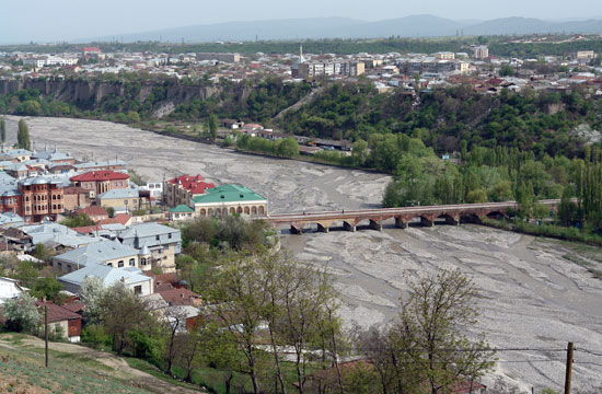
Guba city is located on the Bank of Gudialchay River and on the north-eastern slopes of Shah Mountain, which is part of the Greater Caucasus range. The distance from Baku is 168 km, and the height above sea level is 600 meters. Information about the history of Guba city and Guba Khanate, people who made this country famous can be found in Local History Museum. The House-Museum of a famous public figure, writer, and educator Abbasgulu Aga Bakikhanov is also located here. One of bakikhanov's books, "Gulustani — Iram", is devoted to the history of Azerbaijan. In essence, this book is the first scientific work on the history of Azerbaijan. There is also a carpet weaving center in Guba.
"Chichi", "Sirt Chichi", "Gimil", "Jimi", "Yerfi" carpets woven in this area are adornments of a number of museums and private collections of the world.
Historical monuments such as Sakina Khanum mosque, Juma Mosque, the mausoleum of the 16th century, ancient Eastern baths have been preserved in the city. In the first half of the 18th century, the present Guba, Davachi, Gusar, Khachmaz, Khizi, and Siyazan districts were united in the form of Guba Khanate. Initially, the center of this Khanate was Khudat city, but later Guba Khan Huseynali turned Guba into the center of its Khanate and moved his residence to Guba. Fatali Khan, the most famous ruler of Guba Khanate, tried to unite retail khanates of Azerbaijan under his leadership. He subjugated entire north-eastern Azerbaijan from Derbent to Lankaran. At that time, Jews were invited to settle in Guba, on the Left Bank of Gudyalchay. This settlement, formerly called the Jewish Sloboda, has been called the Red settlement since 1926.
Dagestani Khans have always been a source of danger for Guba Khanate from the North. When Russia began to show geopolitical interest in the Caucasus and Transcaucasia, it became much more difficult to protect the borders of Guba Khanate when it decided to establish its regime here. And at the beginning of the 19th century (in 1813) Guba Khanate became part of the Russian Empire.
Guba is a small town, but the territory of the present Guba district, located on the north-eastern slopes of the Greater Caucasus, is very picturesque and you will plunge into the world of beauty as soon as you get out of the city to the Canary Islands. Both Azerbaijani and foreign tourists never leave this region in the spotlight. And bakuvians, especially those who come there in their cars to rest in Guba, often visit the recreation area from Guba on the shore of the Yalama sea, not far from Guba. Those who relax in Yalama (Nabran) do not miss the opportunity to enjoy the rest on the Caspian coast, to enjoy the foothills of Guba forests, to enjoy numerous Springs and natural landscapes. Guba district is one of the most beautiful parts of our country. Given its proximity to the capital, the location of the forest zone with the Caspian coast, numerous tourist bases, and recreation areas, this region is of great importance as a recreational zone of the country.
KHACHMAZ
KHACHMAZ region, which occupies part of the Samur-Shabran lowland, is located in the northeast of Azerbaijan and borders Russia in the North. The main highway and the Baku-Moscow railway pass through the territory of this district. The climate of the region is mild-hot, semi-desert, and dry steppe. But more than 20 hectares of area in the district are covered with forests. There are several rivers, 3 artificial lakes, numerous thermal and mineral springs here.
On the border with Dagestan, there was a road before. The occupier Scythians, alan, and hunn tribes followed this path. For this purpose, the defense fortification near Caspian, which reached the territory of the present Khachmaz region, was built. One of the ancient city-castles at the beginning of the 18th century — Khudat (which literally means "Gifted"). It has become the capital of Guba Khanate. Near the city of Khudat, groundwater resources are especially abundant. In 1914, a drinking water pipeline was built here from the village of Shollar to Baku.
Traces of Neolithic and Bronze Age human settlements were found in the whole territory of the region. According to scientists, the toponym "KHACHMAZ" is connected with the name of Khachmatak or Khachmat tribes of the Comme Hunn tribes. Subsequently, they became entangled with the local population. It is interesting that one of these tribes moved from the territory of Khachmaz region to the present Oguz region and created Khachmaz village of the same name, then Khachmaz fortress.
About 60 historical and cultural monuments are preserved in this region. However, according to archaeologists, the number of such monuments should be much higher, since ancient times the population has been densely populated in this region. Human settlements and mounds of the Bronze Age were discovered near the villages of Molla Burhan, Hulovlu, Garajig, Hasangala, human places of the Middle Ages near the villages of Janakhir and Bostanchi. The Sheikh Yusif mosque (15th century) in the village of Shikhlar refers to the early periods when architectural-mausoleum complexes were established. Subsequently, in the 16th-17th centuries, such complexes became more widespread. Mosques of the 19th century in the villages of Morugoba, Tagaroba, Uzunoba, mosques of the 15th century in the village of Garagortlu, and madrasas were preserved.
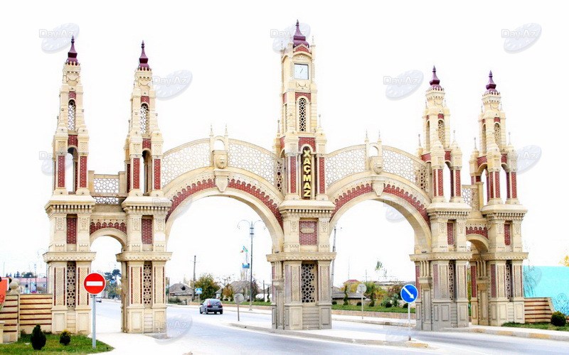
The administrative center of the Khachmaz district is Khachmaz city. Its distance from Baku is 157 km. A special faculty was opened in the local Lyceum because carpet weaving was developed more widely from traditional folk art. Visitors often come here to watch how they weave beautiful carpet patterns with the delicate fingers of young masters. Patterns of these carpets have been passed from generation to generation for centuries and are still preserved.
Visitors to Khachmaz can stay here at “Elit N Hotel”. The second place in the country for its size and improvement is located in the territory of Khachmaz district. Occupying an area from Mukhtadir settlement to Nabran settlement and a little farther along the coast of the Caspian Sea, this recreation area has many tourist bases and boarding houses.
NABRAN
Nabran is the largest creative region located on the shores of the Caspian Sea in Khachmaz. An interesting feature of this zone is that the forest begins immediately after the sandy beach, located in a small area. Various tourist bases, camps, boarding houses, and rest houses are located in this forest. Their conditions are very diverse-there is a wide choice of comfortable hotels of the "luxury" type, from abad cottages for several people to tent camps.
GUSAR
District center-Gusar city. Gusar bordering Dagestan is located in the northeast of Azerbaijan at a distance of 35 km from Khudat railway station. The name of the region is derived from the name of the tribe "Khisar", which once lived in this area and later disappeared as a result of historical ethnogenesis. Now in this region mainly live representatives of the Lezgin nation.
The landscape of this area is marked by an alternation of mountains and valleys covered with forests. Broad-leaved trees-hornbeam, oak, and birch trees are more common here. Asgaril, sumakh, Hawthorn, dog-rose, wild fruit trees, wild grapes, various kinds of medicinal plants grow in Tugay forests of the river deposits. Beech forest called "ALISTAN BABA forest" here (Area of 7 hectares) is protected by the state. The fauna of the Gusar region is also rich. Here live wolves, bears, Boars, mountain goats, eagles, owls, and other birds and animals. In order to preserve hunting and hunting industrial species of fauna and restore their prime number, "Gusar" Reserve was established (an area of 15 thousand hectares).
There are beautiful waterfalls in mountain gorges. The most popular of them are the waterfalls of Laza and Shahnabaz, which attract tourists and lovers of the wild nature of the Caucasus. The mountains and peaks of the Gusar region attract climbers. In recent years, local waterfalls have become a place for athletes who like to climb the icy mountains in winter. You can walk from Laza village to Khinalig village of Guba district. This route is preferred by lovers of pedestrian tourism.
Those who walk along the ecological tourism route from Gusar to Laza waterfall can camp in Anik village. The ruins of the fortress walls of the 13th century and the ancient mosque building are in good condition near this village. And near the village of Laza you can stay at the rest base" SUVAR".
The length of the route from Gusar to the village of SUDUG is 75 km. On the slopes of the Shah mountain, you can see the mausoleum of Sheikh JUNEYDAN (16th century), the grandfather of the founder of the Safavid state of Azerbaijan Shah ISMAIL Khatai, in the village of Hazra.
Like all Azerbaijani lands, one can see evidence of the ancient culture and way of life of this person in Gusar. The remains of ancient mausoleums, mosques, ancient human settlements, and fortresses have been preserved in Hazra, Hil, Balagusar, Anik, Yasab, Kohna Khudat, Gunduz gala villages.
The administrative center of Gusar district is located 183 km from Baku. The Great Russian poet Lermontov once visited this city. Now a museum bearing his name has been created here.
The most common types of folk art in Gusar are carpet weaving. Flat-woven SUMAKH carpets are more popular both at home and in a shop in the city center. The biggest carpet bench in the Republic has been installed in this workshop. Up to 10 Carpet Makers can work on this machine at the same time.
Gusar district attracts tourists visiting Azerbaijan not only as a functional ski tourism complex, but also the natural wonders, culture, and traditions of the people living here are very interesting. The Pearl of all tourism industry of Azerbaijan, the complex of winter and spring sports facilities "Shahdag" is located at 2544 m above sea level, on the mountain slopes. The existing hotels here are located at an altitude of 1640 meters: "Pik Palace Shahdag", "Park Chalet, Shahdag", "Zirve Hotel Shahdag", and "Shahdag Hotel & Spa", but this is not the end for these places. If you are an excellent driver, you can see the highest mountain tourist center in Azerbaijan — Recreation Area "Suvar". This is “Suvar”, located at an altitude of 1850 m above sea level. Near the complex, there are beautiful waterfalls — 2000 m high — Laza and Shahnabat twin waterfalls. Local waterfalls have one characteristic feature — it is very-very convenient to hold winter competitions here because they do not freeze in winter.