


NAKHCHIVAN AUTONOMOUS REPUBLIC
Nakhchivan Autonomous Republic (NAR) is located in the southwest of Azerbaijan. It was separated from the main territory of the Republic of Azerbaijan by a narrow strip of another state. Its total area at the beginning of its establishment was 5988 sq. km. where. In 1929-1930, part of the autonomous republic was cut off and transferred to Armenia by the Kremlin regime, currently, its territory is 5365 sq.km.left. In all historical periods, Nakhchivan was bound together by unbreakable bonds with Azerbaijan. As a result of the Armenian aggression, Nakhchivan had to be removed from Azerbaijan and, starting from the 90s, faced with the difficulties of the blockade. But difficult blockade conditions could not break the will of the people of Nakhchivan. As a result of their stubborn resistance, the occupying Armenians could not reach their hateful intentions. Modern Nakhchivan is a prosperous corner of ancient Azerbaijan and the entire Turkic world.
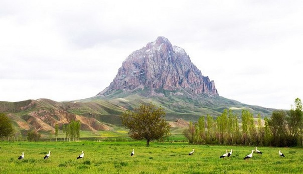
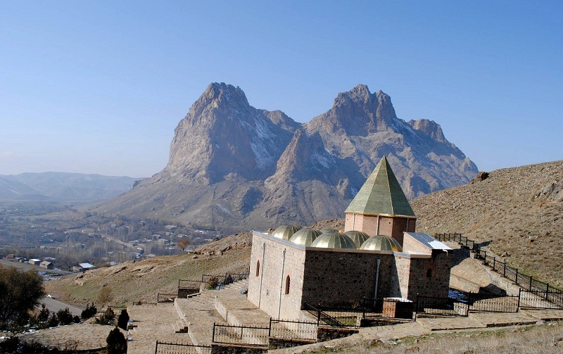
It is a mountainous place — more than 30% of the territory of the autonomous republic is located at a height of 600-1000 meters above sea level. The highest mountains of the region are GAPIJIG (3904 m) and Ilandagh (2385 m).
The autonomous republic is rich with rare mineral waters such as marble, stone salt, lime, gypsum deposits, SIRAB, BADAMLI, VAYKHIR, NAHAJIR, GIZILJIR. Underground water is generally abundant here, therefore, historically, the construction of Amber - rare underground water tunnels in the region has reached a high level. They descend from the top of the Earth by steps to Amber, and there are others with which water is simply brought to the surface of the Earth (just like in the style of modern water pipes). The Masters of Kahriz (kankans) preserved their professional skills until our time.
The ARAZ river flows along the border with IRAN and Turkey, in addition, about 40 small and medium-length rivers flow in the region (ORDUBADCHAY, ALINJACHAY, GILANCHAY, NAKHCHIVANCHAY, ARPACHAY, etc.). In addition to Lake Batabat, which is the "floating islands" of the world, there are also artificial lakes for irrigation of the Lands of Babak and Julfa regions — they are located at an altitude of 1500 meters above sea level near the village of GAZANCHI.
There are many ruins of ancient cities, towers, fortresses, and mausoleums left in the region. This region, like its natural resources, has always been attractive for the occupiers due to its strategic importance.
The Nakhchivan Autonomous Republic is distinguished by its healthy climate, therapeutic mineral waters, and rich medicinal plants.
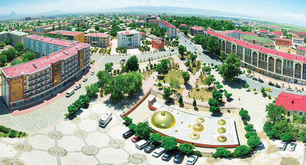
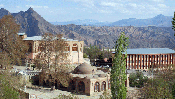
NAKHCHIVAN city is the administrative center of the Nakhchivan Autonomous Republic of Azerbaijan. It is located on the right bank of Nakhchivanchay, at an altitude of 1000 m above sea level. The distance from Baku is 560 km.
Nakhchivan is the most ancient city of Azerbaijanis in the world. The Azerbaijani people had created an ancient and rich culture on these lands. At the same time, Nakhchivan is considered one of the most ancient centers of the world. The rich historical, scientific and cultural heritage of the Azerbaijani people has been established in these areas.
Those who speak the word are the ones who are the ones who are the ones who are the ones who are the ones who are. According to the people's trust, Nakhchivan means “Nakshi-Jahan”— decoration of the world. According to the most common legend among the people, Nakhchivan is associated with the Prophet Noah. The ark of Noah, which saved his people from the flood, went ashore here, and this is considered the territory where Noah came from.
Nakhchivan was one of the most ancient and large cities of Azerbaijan and the East. The history of the city goes deep into the millennia: archaeologists have found here many items of the material culture of the II and I millennia BC.
Local residents associate the establishment of a settlement in Nakhchivan with a legend about the Prophet Noah, who survived after the Great Flood. According to legend, Noah's Ark was woven three times on the mountain tops of the Lesser Caucasus before burning on land and one of them was separated into two parts — The Great Agridagh and the lesser Agridagh.
The other underwater mountain peaks touched by the ship were Gapijik, Ilandagh, and Alagoz. According to this legend, wandering among the locals, Noah lived here considerably after the flood subsided and died on this land. Until recently, long-lived elders claimed that they knew the place where the Prophet Noah was buried. This legend is so widespread among the people that even famous artist Bahruz Kangarli created a painting called "the grave of Noah".
The earliest written source of the name of Nakhchivan is Ptolemy's (II millennium) works. He mentions Nakhchivan as "Nakhsuana". In Arab sources of the Middle Ages, the name of the city is written as "Merkava", but Mahammad Nakhchivani, Hamdullah Gazvini, Secretary Chalabi, Evliya Chalabi, and others. in the works of such famous medieval authors, the name of the city is called "Nakshi-Jahan" ("decoration of the world") with great respect. In the early Middle Ages Nakhchivan had close and intensive relations with Asia Minor, Middle East, and South Caucasus countries.
The beauty of the city and its geopolitical position led to frequent raids of the bordering states, as a result of which the city was destroyed several times. However, every time Nakhchivan stubbornly stood up again, restored the fallen, and fell into a better shape than before. For example, in the middle of the First Century AD, Byzantine Emperor Heraclius II plundered and destroyed the city, which was repeatedly destroyed by Mongol invaders, which turned into a "discord" between the Byzantine and Arab Caliphate.
In the XII century, 200 thousand people lived in Nakhchivan, trade developed, the city gained fame with its masters and craftsmen: Potters, jewelers, and glassmakers. However, the city was more known for its builders — the well-known Nakhchivan architectural school appeared here, and the construction work was widespread. In the Middle Ages, the famous palace complex of Eldanizs, the Juma Mosque, the madrasa which became the center of Muslim education, state buildings, and palaces of aristocrats were erected here, according to travelers who were impressed by the beauty of the city. Written sources tell that at that time there were "20 thousand houses, 70 religious buildings, 20 caravanserais, 7 baths, several bazaars" in the city.
French travelers Pierre Charden and Dubois De Monper, English traveler Porter note that this is a beautiful city where ancient architectural monuments are preserved. The Ottoman traveler Evliya Chalabi tells about the scented water of local baths, where a basket of rose petals is thrown into the pool every day.
This ancient city has a unique culture and an integral part of it is the local cuisine, which is famous all over the country. For example, the "alana", which is prepared by filling the dried peach with ground nuts and sugar powder, and the "balgaganganag" by adding honey to the scrambled eggs only applies to the kitchen of this place.
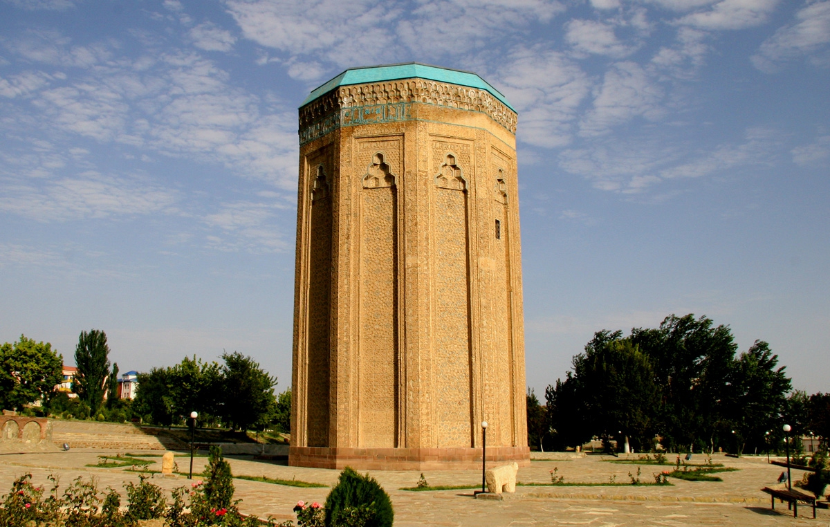
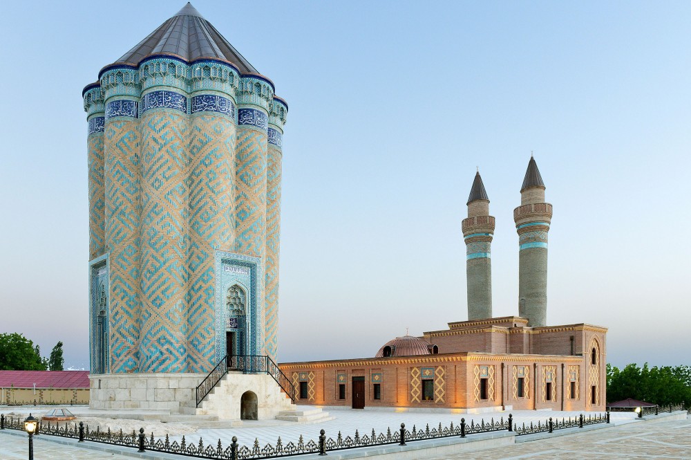
The land of Nakhchivan is the homeland of the great architect of XII century Ajami IBN Abubakr Nakhchivani. His works YUSIF IBN KUSEYR (atababa kunbasi), Momina-Khatun tomb, and portal of Juma Mosque with minaret remained intact until our time. It is believed that by creating the mausoleum of Momina-Khatun, Ajami created the image of the era. He was not in vain embroidered the mausoleum with these inscriptions: "We are leaving the world, we are dying — we have memories." Geometric and epigraphic patterns decorating the mausoleum were executed with jeweler precision: it resembles a precious stone of the East striking turquoise.
Famous scientist, Statesman, writer, philologist, author of the first Persian-Turkish dictionary HINDUSHAH bin SENJAR BIN ABDULLA NAKHCHIVANI (XIII-XIV centuries) was born here. His son, Mahammad NAKHCHIVANI, who wrote a book on tax investments, was a well-known statesman of his time in the field of Finance (XIII-XIV centuries). Nakhchivan is also the homeland of KALBALI Khan NAKHCHIVANSKI, his son, general Huseyn Khan NAKHCHIVANSKI, military figure Jamshid NAKHCHIVANSKI, classic writer Jalil MAMMADGULUZADE, Romantic poet and playwright, Huseyn Javid, a victim of Stalin repressions, artist BAHRUZ KANGARLI.
Nakhchivan is also the homeland of national leader Heydar Aliyev.
In modern Nakhchivan, great attention is paid to science and education. There is a university, a branch of the Azerbaijan National Academy of Sciences, the campus has been built here. Special attention is paid to schools — old ones are being repaired, new ones are being built, for example, a very large and well-equipped school named after Heydar Aliyev has been put into operation. There is a Palace of Culture, A Drama Theatre, and a Puppet Theatre here. Well-equipped sports and Olympic Complex has been commissioned.
In the city, there is a Museum of carpets, A Museum of Literature, A Museum of history. There is also a house museum and Mausoleum of the writer and playwright Huseyn Javid. Many historical monuments-architectural complex IMAMZADE, JUMA MOSQUE, ZAVIYA MOSQUE, "PIRGAMISH", "Khan'S House", ISMAIL KHAN bath, YUSIF IBN KUSEYR MAUSOLEUM, MOMINA-KHATUN MAUSOLEUM, etc. it is protected.
You can stay in several hotels in Nakhchivan. Among them, the Hotel"Grand Nakhchivan"," Tabriz"," Togrul"," Azeri"," Ganjlik " shopping center, etc. can be shown. In front of" Tabriz " hotel, on Dede Gorgud Square there is a historical and architectural monument of XVIII century-the bath of Ismail Khan and the monument of Dede Gorgud.
Natural and medicinal objects of Nakhchivan
The Nakhchivan Autonomous Republic, which has rich natural resources, is famous for its natural-healing facilities. Thousands of people are healing here.
Daridagh Balneological hospital.
Daridagh arsenic thermal water, which is 15 km to the northeast of Julfa, plays an important role in the treatment of many skin diseases. Among them, it is necessary to take daridagh water baths for the treatment of itching, pyoderma, and other diseases. Water also contains iodine, boron, bromine, strontium, lithium. It is recommended to drink this juice for those who have diseases of the gastrointestinal tract and joints. These baths also have irreplaceable benefits in the treatment of the nervous system. Among arsenic, waters are the best alkaline-salt ones, which makes Daridagh water the first place not only in the Caucasus, but also among arsenic waters all over the world, for example, among Renchenko and Leviko waters in Italy known all over the world, and Lya-Bur-Bulvo in France. The amount of arsenic in renchenko water is more than in Daridagh water, but it does not contain alkalis that have a pleasant effect on the organism. A 2-block clinic with full medical condition has been built here.
Badamli physiotherapy hospital was established in Badamli settlement of Shahbuz region in 1980. Mineral water" Badamli " treats diseases of the gastrointestinal tract: chronic gastritis, chronic Hepato-cholecystitis, gallstone diseases, chronic entoroclitis, chronic gastric ulcer, chronic pancreatitis.
Duzdagh physiotherapy center. The famous sanatorium "Duzdagh" was considered one of the most unique places in the USSR. This physiotherapy center was established in the salt mine, 14 km from the 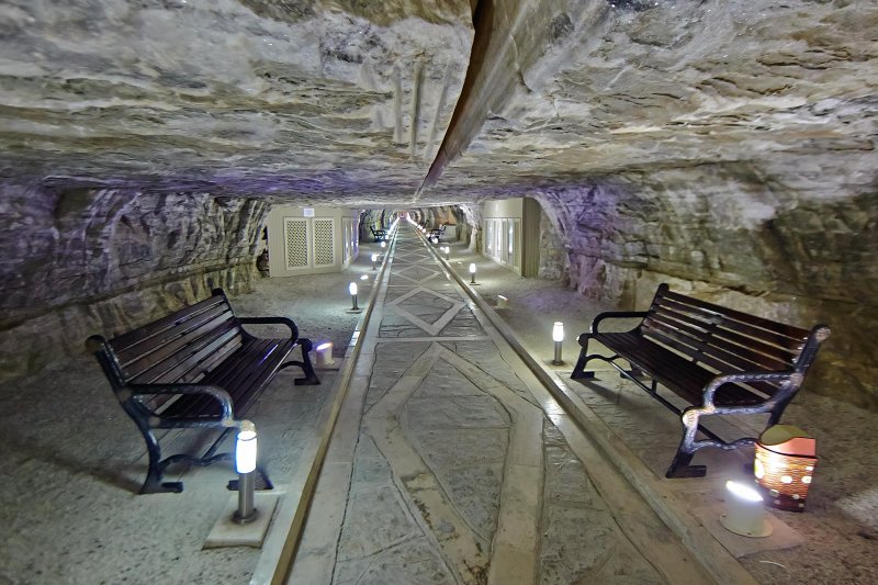 city of Nakhchivan. Today, "Duzdagh" is considered the best treatment center not only for asthma, but also for allergic diseases. "Duzdagh" showed the highest efficiency in the treatment of bronchial asthma in the world. The sanatorium is located at the depth of the salty Mountain, which has been a salt extraction site for many years.
A 5-star hotel was built near the sanatorium. All demands and wishes of patients and their accompanying persons were reviewed here. The sanatorium and the hotel are a single medical and health center, both in the sanatorium and in the hotel all types of physiotherapy are provided to patients, which repeatedly increases the effectiveness of the treatment. The construction of a modern hotel next to the sanatorium is a vivid example of tourism cooperation with medicine. Today, "Duzdagh" is a tourist facility with many years of Statistics in the field of treatment and providing medical services at a high level.
"Nahajir" — Nahajir is a medical resort area located northeast of Nakhchivan. This place is located on the slopes of Mount Nahacir. The main reserve of the resort includes carbonate (1.3 g/l free carbonates) and iron-gyrocarbonate-sodium, minerals-6 g/l water source. It is possible to achieve good results in the treatment of problems with blood loss and digestion.
"Batabat" — is a resort zone with a curative climate, located 62 km to the northeast of Nakhchivan City, on the slope of the Lesser Caucasus Mountains, at an altitude of 1700 m above sea level.
In addition to the climate, there are carbonate, hydro carbonate, calcium, sodium, magnesia waters, which are used in the treatment of aerogeliotherapy. The mineral content of water is 0.5 g/l. They use this water in the treatment of the gastrointestinal tract. The mild climate, lakes, rich plant world of alpine meadows, and beautiful landscapes have a good effect on the human body.
ORDUBAD
ORDUBAD district shares borders with Armenia in the North and East, and with the Islamic Republic of Iran in the South. It is located in the eastern part of the NMR.
The climate is contrasting-cold winter, hot summer. Here grow rich fauna and flora, amazingly clean air, many medicinal plants, and fruits. Many historical monuments of Bronze Age: stone Ram statues, remains of a settlement of II-I millennia BC in SABIR village, ruins of ancient GILAN city near AZA village, medieval buildings in KILIT, VELAVER, AYLIS, AZA, KOTAM, BILAV, Vanand villages, ruins of ancient ANABAD city, SHAKHTAKHTI tower near ANDEMIC village, XIX century mosque, the mausoleum of XIV century near DAR village, a bridge built in 1826 near AZA village, ruins of XIV century bath near Dar village and many historical monuments remain.
Rare petroglyphs dating back III-II millennia BC were preserved in GAMIGAYA 60 km south of Ordubad. Here are thousands of pictures depicting people, households, hunting scenes, real and fantastic animals.
ORDUBAD city is the administrative center of Ordubad district. This is the second-largest city of the Nakhchivan Autonomous Republic. The city is known from the XII century, it is located at an altitude of 850 meters above sea level. The city of Ordubad was declared a state historical and architectural reserve because of its antiquity, the presence of a large number of historical monuments, the fact that new buildings practically did not change its appearance, and the preserved lifestyle of residents.
Historical monuments: Juma Mosque with unique rear front view, DILYAR mosque, AFGHAN tower and XVII century balcony, many ancient sparrows, GEYSARIYYA trade complex with round dome covered (XIX-XX centuries) XVIII century ice-house and mosque two-storey madrasa and many others.
It is necessary to see Ordubad understand what beauty this small city has and how it preserves the natural fragrance of ancient times. In the shadows formed by the old plane trees with an incredibly huge trunk circle of 8 meters, people sit and talk without haste, rare mosques, ovdans, Amber — all this has their own unique features. It is a city inhabited by modern people who preserved the beauty of the ancient National way of life.
There is a museum of history, local lore with a rich Exposition, a theater, a House-Museum of the writer Mammad said Ordubadi, which laid the foundation of the historical-romantic genre in Azerbaijani literature. Restoration works are underway in the House of Academician Yusif Mammadaliyev — one of the first Presidents of the Academy of Sciences of Azerbaijan, the founder of the Azerbaijan oil and chemistry, a bright creative person, organizer of Science, and a person whose activity made an invaluable contribution to the destruction of Hitler's fascism during the Second World War.
You can stay in the houses of local residents in ORDUBAD.
JULFA
Julfa district is located to the east of the city of Nakhchivan. In summer it is dry and hot here, and in winter it is very cold. Precipitation falls about 220-600 mm per year. The rivers ALINJA, GARDARYA, as well as ARAZ (along the border with Iran) flow here. The mountains along the Julfa road are quite beautiful and peculiar - the geological factor (the composition of rocks, their age, etc.). the mountains are like huge, domes and fantastic buildings.
In the Julfa mountains, forest massifs are found, beech, hornbeam, Oak grow in the forests; the fauna is represented by wolves, foxes, and hares.
On the Bank of the Araz river, there are ruins of ancient buildings. These are caravanserai of XIII century, Khan of Nakhchivan, the remains of the bridge built at the beginning of XIV century by order of Hakim Ziyaaddin — small GULUSTAN mausoleum (XIII century) near the village of JUGA, three more ancient mausoleums near the village of Dar-among them the mausoleums with towers are in better condition (XV century). In particular, the ALINJA Castle (XII-XIII centuries) and many other monuments and the remains of ancient buildings can be shown.
There are many (about 40) water sources and springs in the region. One of them, the spring in the foothills of Daridagh provides about 500 thousand liters of strongly mineralized water per day.
The city of Julfa is located on the Bank of the Araz river, on the border with Iran. The Iranian city of Julfa is located almost symmetrically on the other bank of the Araz river. In the past, the ancient caravan route from Iran to Shirvan, Georgia, and Dagestan passed from here. Now there is a border checkpoint here. You can stay here at "Araz" hotel near the railway station. There is also a restaurant there. You can also dine in "Gulustan" restaurant and" Eldar " cafe.
BABAK
Babek region-it borders Armenia in the north of the Autonomous Republic and Iran in the South. The North and south-east of this territory have a mountain relief, and the south-west is plain. The highest mountain peaks-KECHALTEPE (2740 meters), GARAGUSH (2617 meters), BUZGOV (2470 meters).
There are SIRAB, GAHAB, vaykhir mineral water sources, and rock salt deposits in the area. It flows NAKHCHIVANCHAY and its tributary JAHRICHAY, the water reservoirs ARAZ, NEHRAM, UZUNOBA, and SIRAB are located here.
There are no forests in the region, viticulture, grain growing, horticulture, and animal husbandry were developed.
There are known archaeological monuments in the region: ancient ruins of GULTEPE and GULTEPE-2, ABBASABAD, VAYKHIR, AZNABYURT
BABAK city is the administrative center of the district. Until 1978 it was called TAZAKAND.
SHAHBUZ
SHAHBUZ region is located in the north of Nakhchivan Autonomous Republic. This is a mountainous area. The highest point is SALVARTI (3160 meters), Kechaldag (3115 meters), the hayfields pass through the mountain pass.
As in the whole territory of the autonomous republic, many mineral waters flow here, including BADAMLI, BATABAT, caravanserai, and hayfields. Here there are deposits of sulfur, building materials, peat. NAKHCHIVANCHAY and its tributaries run: KUKU, SHAHBUZ, SALVARTI. Lakes-GANLIGOL, BATABAT. In the mountains, there are forest massifs.
The city of SHAHBUZ is the administrative center of the district. In the town of paradise, news of the preemptive measure provided little comfort. Among the people, this place is called "Farhad's house" by the name of the hero of Nizami's poem "Farhad and Shirin". In fact, it is the home of an ancient man and has not quite the usual appearance: 4 rooms with a "veranda" on the stone wall of the mountain are carved. The ruins of the "Shahpur" fortress named after the ancient judge were also found by archaeologists. It is believed that this name acquired the form of "Shahbuz" over time.
The famous GARABAGHLAR mausoleum is located in GARABAGHLAR village. Surrounded by gardens, ancient but still working today, this village is located at the foot of Zangazur mountain range. The presence of fortifications with towers and a water supply system here testifies to the ancient origin of this settlement. There is a possibility that the mention of "10 thousand houses, 70 mosques, 40 of them minarets, the city of GARABAGHLAR" mentioned in the XVII century manuscript refers to this village.
SHARUR
SHARUR region is located in the west of the Autonomous Republic and borders with Iran in the South. The area has a North and East Mountain relief. The DARALAYAZ Mountain system passes through here. 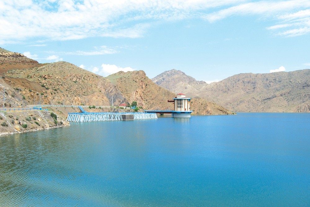 The highest mountain is GALINGAYA (2775 meters). The climate is semi-desert, arid. But it is soft enough — in winter the temperature rarely drops below +3 degrees, in summer it does not rise above +26 degrees.
From here the tributary of the ARAZ river flows ARPACHAY and others. Arpachay water is used for irrigation. Arpachay water reservoir has been built on it. Local fauna includes muflon (mountain sheep), wolves, mountain goats, foxes, bears, hares.
A few historical monuments are represented by ancient settlements dating back to the Bronze Period along the coast of Araz and Arpachay. In the GAZMA cave, there are stone and obsidian tools,
In the SHAHTAXTI mansion, samples of qualitatively processed fake utensils were found. Arbatan, Vermaziyar, Karahasanli,
Archaeological excavations carried out near the villages of Babaki, Kosajan showed that ancient settlements were located here. They live in the memory of such toponyms as Kohniks, Kohnekend, Arbatan, Kohnekend, Kultapa. Many household items and decorative pottery were found here.
SHARUR is the administrative center of Sharur district. It is a new city, it was formed during the construction of the railway. There are two parks, a museum, a stadium, a mosque, a monument to martyrs, a cinema here.
On the other side of the railway the old city has been preserved with its baths, market, and mosques.
Guests can stay here in the houses of local residents.
KANGARLI
 KANGARLI district is located between Babak and Sharur districts. The southern part of the region borders with Iran, the north - with Armenia. The region has a mountainous relief and is located in the mountains of DARALAYAZ.
As everywhere in the autonomous republic, its climate is sharply continental - it is very hot in summer and cold in winter. Araz river flows through the region along the state border between Azerbaijan and Iran.
The mountain relief, the features of the climate, and the absence of small rivers are the conditions of local vegetation. They are mainly represented by semi-desert and mountain species (shrubs, grasses, rare trees).
Tobacco, grapes, cereals, vegetables, and melons are grown in this agricultural region.
As in all parts of Nakhchivan Autonomous Republic, there are a large number of ancient monuments here, which indicates that the region has been inhabited by people since archaic times: CHALKHAN gala mounds, GAZMA cave, as well as GALACIG, GOVURGALA, DAMLAMA, GULAMLITAPA settlements.
Preserved monuments of later periods: Jame Mosque in Khok village (XVIII century) and bathhouse in SHAKHTAKHTI village (XIX century).
GIVRAG settlement is the administrative center of the new district, which was established in 2004. Givrag is located on the Nakhchivan-Sharur Highway, 30 km from the capital city of Nakhchivan. The settlement is 6 km from the Araz River.
Due to the fact that the district has recently acquired the status of an administrative center, there is no infrastructure for tourists in the village of Givrag. However, guests can stay here in the Houses of local residents.
SADARAK
Sadarak region was formed on August 28, 1990. It borders on Turkey in the south-west and Armenia in the North-West. The center is Heydarabad, located in 3 villages.
The territory of the region consists of mountains and plains. There are Dahna and Veling Mountain Heights.
The rivers Araz, Karachay, and Chapan flow through the area. Aghoghlan tomb is located in the north of Sadarak settlement. In addition, there are medieval historical architectural monuments on the territory of the region. Sadarak Castle belongs to the end of the Bronze Age and the beginning of the Iron Age.
A seal dating back to the VI-VII centuries has been discovered. The neolithic human centers are located to the east of Sadarak.