


Formation
The formation of the Caspian Sea began 10 M years ago, and during this period of time several changes of the seawater level, as well as the recurring transgressions and regressions, took place. During the Tertiary period (which began about 70M years ago) the Ponto-Caspian basin was isolated from the Tethys Ocean and its southern seas and gradually transformed into a stand-alone inland basin. At the Late Pontian and Middle Pliocene time (10 M years ago), the vast inland Sarmatian basin, which extended from the Black Sea to the Caspian Sea, was divided into several parts with the stand-alone Caspian Sea. During the Quaternary period (500 years ago), the Caspian Sea was linked to the Black Sea by the Kuma-Manich depression. The fluctuation of the Caspian Sea water level ranged about 300 m during the last geological period of time. Sometimes, sea bottom in the entire North Caspian and partially Middle Caspian sectors underwent subaerial exposure, whereas South Caspian-Lankaran basins remained submerged under the water surface.
Physiography
The five littoral states have a shoreline of 6,500-6,700 km (7,000 km with Islands) shoreline. The shoreline length in each of the littoral states is as follows: Republic of Azerbaijan — 955 km, Kazakhstan — 2320 km, Islamic Republic of Iran — 724 km, Russian Federation — 695 km, and Turkmenistan — 1200 km.
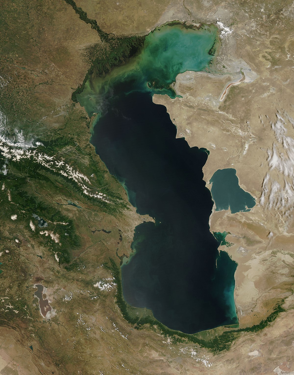
Caspian Sea is a latitudinally extended basin similar to the Latin letter "S" that is located in the area limited by 47 17 North latitude and 36 33 southern latitude coordinates. Its latitudinal length approximates 1200 km, average width measures 310 km with maximum and minimum width values 435 km and 195 km respectively. Due to recurrent sea-level fluctuation, its offshore area and the number of water masses are also variable. Currently Caspian Sea level measures 26.75 m below the world ocean level. Caspian offshore area at its current sea-level position amounts to 392,600 sq km with the amount of water volume measured 78,648 km, and this volume covers 44% of the overall amount of lacustrine water all over the world. Caspian Sea maximum depth measures 1025 m and, in this context, it is comparable with such ones as the Black Sea, Baltic Sea, and Yellow sea, and deeper than Adriatic, Eagan Sea, Tirren, Sulu, and other seas.
Caspian Sea drainage area amounts to 3.1-3.5th. sq km extending over 2500 km from the north to the south and up to 1000 km from east to west that covers 10% of the world's closed drainage areas. The following 9 country areas entirely or partially are included in its drainage area: Azerbaijan, Kazakhstan, Armenia, Iran, Georgia, Uzbekistan, Russia, Turkey, and Turkmenistan. Due to the tremendously large and closed type drainage area, the Caspian Sea could be referred to as a Global-scale climate identifier.
Due to geomorphology setting and physiographic conditions, the Caspian Sea is divided into three different sectors: the North, Middle, and the South sectors. Both imaginable lines extended across the Caspian Sea from Chechen Peninsula to the Tub-Karagan spit, and another one extended from Chilov Island to Hasangulu spit, is referred to as the borderlines between its northern and middle, as well as between its middle and southern sectors, respectively. Both Gulali shoal that begins from Tub-Karagan Peninsula and further on the Mangishlag sill extended through the shallow water (10 m deep) from Chechen Peninsula serve as the natural border dividing the North and Middle Caspian offshore areas. Middle and South Caspian sectors are divided from each other through submarine elevation extended between the Absheron Peninsula and Cheleken Peninsula, known as Absheron sill. The spatial coverage proportion of the North, Middle, and South Caspian sectors amounts to 25%, 36%, and 39%, respectively. Water column maximum depths within the North, Middle, and South Caspian sectors amount to 25 m, 788 m, and 1025 m, which averages as 4.4 m, 192 m, and 345 m, respectively.